The Global Positioning System (GPS)
The Global Positioning System (GPS) is a satellite navigational system developed by the United States Department of Defense during the 1970s for military use. Since 1980, GPS technology has been available for commercial use, and is now used in countless applications including navigation, surveying, cartography and vehicle tracking systems. The first GPS satellite was launched in 1978, with at least one satellite per year being launched since that time. In order to provide full global coverage, the GPS system requires a "constellation" of at least twenty-four satellites. Full operational status was achieved by the mid-1990s, when the number of GPS satellites in orbit reached the required number. Because each satellite can remain fully functional for only a few years, new satellites must be launched on a regular basis to replace those that have reached the end of their useful life.
At the time of writing, the GPS constellation consists of thirty-one satellites, providing considerable redundancy in the system. Each GPS satellite is maintained in a medium earth orbit at a height of just over twenty-thousand kilometers, in one of six orbital planes. The orbital period is approximately twelve hours, which means that each satellite orbits the Earth twice each day. The orbits are designed to ensure that a minimum of six satellites are in line of sight for virtually any position on the Earth's surface at any time of the day or night. The position of each satellite is monitored by monitoring stations around the globe. This information is sent to a master control station in the United States. The master control station uses a number of ground antennae to regularly update each satellite with its current position and a clock signal to enable the satellites to synchronise their internal clocks.
Each satellite carries a highly stable atomic clock, enabling the clocks of the entire GPS constellation to remain synchronised to the clock signal transmitted by the master control station to within a few nanoseconds. Each satellite continually transmits status information, including its current position and the time according to its onboard clock. A GPS receiver is tuned to receive signals at the frequencies used by the GPS satellites. A typical GPS receiver can receive signals on up to twenty different channels, although it need only have line of sight to four different channels in order to establish its geographical location and the time difference between its internal clock and the clock on board the satellite.
The GPS receiver can calculate the time taken for a signal from a particular satellite to reach it by comparing the time of transmission encoded in the satellite's signal with the time of arrival of the signal according to the receiver's clock. Since the speed at which the signal propagates is known (i.e. the speed of light) the distance between the satellite and the receiver can be accurately calculated. Together with the satellite position data encoded in each satellite's signal, this information allows the receiver to calculate its longitude, latitude and altitude (usually expressed as height above sea level) to an accuracy of between three and fifteen metres, as well as the current time.
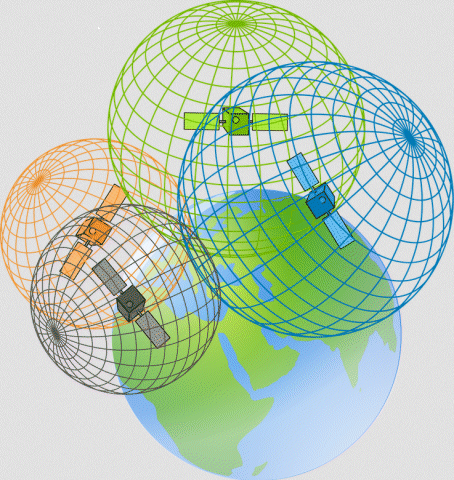
The process by which the GPS receiver calculates its position is called trilateration. This is defined as determining the absolute or relative position of a point in space through the measurement of distances, using the geometry of circles, spheres or triangles. If you know you are at a distance x from satellite A, you can think of yourself as being on the surface of an imaginary sphere of radius x, with its centre at A's coordinates. If you also know you are at distance y from satellite B, you will also be on the surface of another imaginary sphere of radius y, with its centre at B's coordinates. The two spheres will overlap, and intersect in a circle. Your location will lie somewhere on the circumference of that circle.
Now let's suppose there is a third satellite - satellite C - at distance z. Once again, you will be somewhere on the surface of an imaginary sphere of radius z, with its centre at C's coordinates. The overlap between all three spheres, however, now occurs at just two points, one of which will be your location. If you think of the Earth itself as the fourth sphere, only one of the two possible points will lie on its surface. For this reason, three satellites are generally sufficient to establish the latitude and longitude of a GPS receiver. A fourth satellite, however, can be used to provide both greater accuracy and altitude information. Provided the receiver knows the location of each satellite, and the distance between it and each of the other satellites, it can make the necessary calculations.
How trilateration works to determine GPS position